 Catálogo de datos del IEO
Contact for the resource
University of Perpignan, CEFREM
9 record(s)
Type of resources
Categories
Topics
INSPIRE themes
Keywords
Contact for the resource
Provided by
Years
Formats
Status
-
<p style="text-align:justify">The main objective of the observing system MOOSE is to monitor the long-term evolution of the north-western Mediterranean Sea (over more than 10 years) in the context of climate change and anthropogenic pressure in order to detect and identify the trend and environmental anomalies of the marine ecosystem. The MOOSE network aims to establish an integrated and multidisciplinary system in the Mediterranean Sea in accordance with the objectives of the national MISTRALS program (HyMeX, MeRMEX and ChARMeX). The MOOSE system is supported by national institutes (CNRS-INSU, French Ministry of Higher Education and Research) and involved different partners (Universities, IFREMER, Meteo France).</p> <p style="text-align:justify">The MOOSE network includes "multi-scale" measurement capabilities to accurately document the broad spectrum of hydrodynamic processes already identified (large scale eddies, mesoscale eddies, biogeochemical provinces). High temporal resolution measurements are obtained from fixed observatories (moorings, buoys) but their spatial distribution remains insufficient. Spatial variability is of the same order as temporal variability and understanding the evolution of this basin as a whole implies being able to dissociate both. Synergy with other strategies (ships, floats, gliders) is essential for the establishment of an observation network in such a system. To address the issues identified by MOOSE, two key areas of the north-western basin have been identified:</p> <ul> <li style="text-align:justify">The central and western part of the Ligurian Sea, which constitutes a homogeneous system isolated from direct coastal inputs by rivers and where atmospheric inputs are predominant (DYFAMED and ANTARES). It is also one of the entrance passages of the Intermediate Levantine Water (LIW) in the north-western Mediterranean basin.</li> <li style="text-align:justify">The central area of the Gulf of Lion where winter cooling leads to vertical mixing over 2000 m and sometimes to the bottom. The LION site (42°N 5°E) is ideal for studying the variability of winter convection to better understand mixing processes and dense water formation. It also characterizes the variability of the deep particle flow.</li> </ul> <p style="text-align:justify">Currently, fixed observation at these sites is carried out by six moorings:</p> <ul> <li style="text-align:justify">The Planier and Lacaze-Duthiers moorings composed of sediment traps and T/S sensors and current meters, for dense water cascading and particle export studies. These moorings have been set up since 1994 and managed by CEFREM.</li> <li style="text-align:justify">The LION mooring, consisting of a large number of T/S sensors, current meters, and two oxygen sensors, is in the Gulf of Lion convection zone. It has been deployed since 2007, and is managed by CEFREM and LOCEAN. A sediment trap near the bottom has also been present for 2 years in this area (LIONCEAU mooring). The latter will be integrated into the LION mooring in 2019.</li> <li style="text-align:justify">The ANTARES mooring is located in the North Current off Toulon and equipped with T/S sensors, current meters and oxygen sensors to quantify the bacteria activity and organic matter remineralization process in a deep marine environment. It exists since 2004, it is managed by the M.I.O. and the CPPM (Marseille). This mooring is part of the ERIC EMSO since 2017.</li> <li style="text-align:justify">The DYFAMED mooring, in the Ligurian Sea, equipped with sediment traps, T/S sensors, current meters and oxygen sensors to monitor the evolution of the water column, the impact of atmospheric dust deposition and marine particles export to deep waters. It exists since 1988, it is currently managed by the Oceanological Observatory of Villefranche-sur-Mer. This mooring is part of the ERIC EMSO since 2017.
-
Characterizing the variability of hydrology and currentology features and particulate fluxes in the two canyons of Planier (station PL1000) and Lacaze-Duthiers (station LD1000), located at the eastern and western edges of the Gulf of Lion.
-
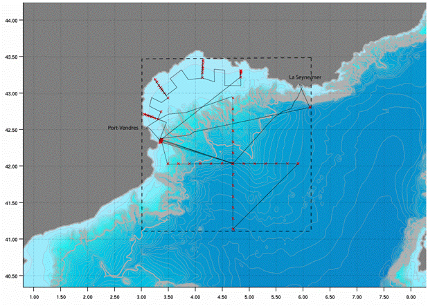
Characterizing the variability of hydrological and current features and particulate fluxes on the continental rise of the Gulf of Lion and in the deep convection zone. Monitoring of deep benthic communities in the western canyons and on the continental rise of the Gulf of Lion. This cruise was associated with the HERMES and EXTREMA projects.
-
Characterizing the variability of hydrological and currentometric features and particulate fluxes on the continental rise of the Gulf of Lion et and in the deep convection zone. Monitoring of deep benthic communities in western canyons and on the continental rise of the Gulf of Lion. This fell under the HERMIONE project.
-
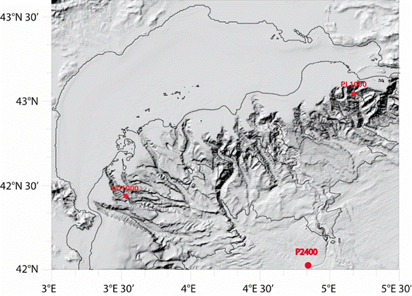
Characterizing the variability of hydrological and current measurement features and particulate fluxes in two canyons of Le Planier (station PL1000) and Lacaze-Duthiers (station LD1000) located at the easternmost and westernmost tips of the Gulf of Lion. Since 2011, setting up a long-term frame of reference in the convection zone - PPS3 trap, buoy zone and LION line.
-
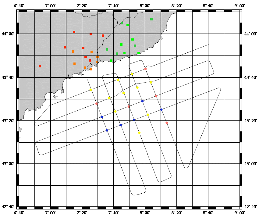
<p>The deep basin and continental shelf of the Gulf of Lion (North Western Mediterranean) are known for the formation of dense water in wintertime by the action of N-NW continental winds. This dense water is formed both offshore and at the coast. The area of Cap de Creus and its adjacent canyon is the main zone where dense coastal water is exported. Dense water dynamics on the continental shelf are also influenced by E-SE storms. Transfers of organic, inorganic, particulate and dissolved matter from the surface to the deep basin and from the shelf towards the slope by these physical processes can influence the redistribution of chemical elements in sediments, as well as the structure and functioning of benthic and pelagic ecosystems. The CASCADE cruise aimed to determine the characteristics of these two physical mechanisms and their numerous impacts, as well as monitoring changes in the hydrology, dynamics, sedimentology and biogeochemistry of water bodies. We propose a qualitative and quantitative estimate of particulate and dissolved, organic and inorganic matter fluxes exported towards the slope and the deep basin by these mechanisms.</p>
-
Characterizing the variability of hydrological and current features and particulate fluxes on the continental rise of the Gulf of Lion and in the deep convection zone. Monitoring of deep benthic communities in the western canyons and on the continental rise of the Gulf of Lion.
-
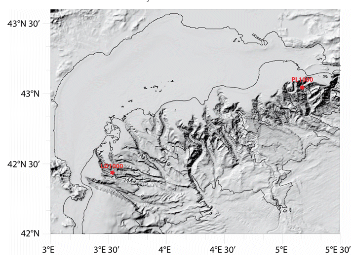
Characterizing the variability of hydrological and current measurement features and particulate fluxes in two canyons of Le Planier (station PL1000) and Lacaze-Duthiers (station LD1000) located at the easternmost and westernmost tips of the Gulf of Lion.
-
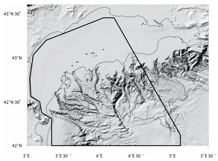
Characterizing the variability of hydrological and current features and particulate fluxes on the continental rise of the Gulf of Lion and in the deep convection zone. Monitoring of deep benthic communities in the western canyons and on the continental rise of the Gulf of Lion.